PT. RADIO NAVIGASI INTERNASIONAL

,

SATELLITE COMPASS™ (GPS COMPASS) Model SC-130

GNSS-powered high accuracy compass

Categories: , Tag:

Features

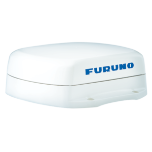
  • SC-130 features a Tri-sensor antenna that provides a high system accuracy for the heading of your vessel

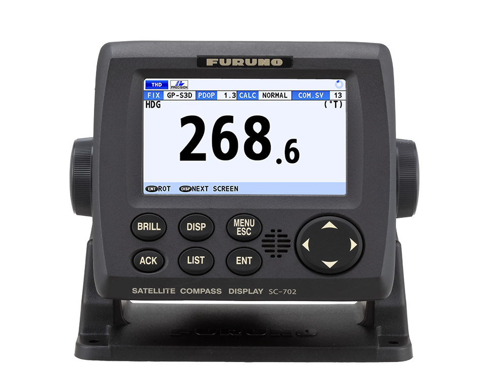
    Provides highly accurate heading data for Autopilot, Radar, ARPA, Scanning Sonar, Current Indicator, Chart Plotter, ECDIS and Autopilot
    ●0.25° (with SC-130)
    Ideal for medium to large vessels navigating in crowded ports and making precise maneuvers, such as berthing.
    ●0.4° (with SC-70)
    Ideal for small to medium boats requiring highly accurate heading .
  • Utilizes GNSS such as GPS, Galileo and GLONASS for high precision

    ・SBAS compatible (EGNOS,WAAS, MSAS)
    ・Provide precise data for SOG, COG, ROT and L/L
    ・Eliminating the problem of not having enough satellites at hand by using multiple types of satellites
  • Speed on 3 axis (Bow, stern and longitudinal) for safe navigating and berthing

  • Type-approved as THD, GPS and ROTI*. Complying with following requirements (For Solas Vessels)

    IMO MSC.116(73) •IMO MSC.112(73) •IMO MSC.526(13) •IMO A.694(17)
    IMO MSC.97(73) •IMO MSC.191(79) •IMO MSC.302(87) •IEC 60945 Ed.4
    IEC 62288 Ed.2 •IEC 61162-1 Ed. 4 •IEC 61162-2 Ed.1 •IEC 61162-450 Ed.1
    IEC 61108-1 Ed.2 •ISO 22090-3 Ed.2 •ISO 20672 Ed.1
    * requires the RD-50 as a display unit
  • Easily integrated into the existing shipboard network via Ethernet

  • Rapid follow-up rate 40°/S

    ・Twice the IMO high speed craft requirement, 20°/s
  • Maintenance free and no recurring cost as there are no mechanical parts

  • Super short starting time – 90 seconds

    ・Once the power is on, it takes about 90 seconds only to start
    (The starting time will slightly differ depending on the equipment)
  • Easy to retrofit by using existing antenna cabling

    ・For SC-50/55/60/110/120 (The LAN_CNV option Kit is necessary)
  • Precision Pitch/Roll data in Analog and Digital formats for vessel stabilization, SONAR, etc.

Specifications

GENERAL

Display
4.3-inch color LCD, 95.04 (W) x 87.12 mm (H)
Heading Accuracy
0.25
Heading Resolution
0.1°,0.01°,0.001° (select from menu)
Follow-up
40°/s
Settling time
90 s approx. (typical)
Position Accuracy
GPS 10m approx. (2DRMS, HDOP<4)
DGPS 5m approx. (2DRMS, HDOP<4)
WAAS 3m approx. (2DRMS, HDOP<4)
MSAS 7m approx. (2DRMS, HDOP<4)
Interface
Number of ports (junction box)
IEC61162-2: 1 port (IN: 1,OUT: 1)
IEC61162-1: 8 ports (IN: 4,OUT: 8)
External beacon input (DATA5 port): RTCM SC-104 V2.3 (RS-485), ITU-R M823
NMEA2000: 1 port
AD-10: 4 ports, for heading output
RS-485 : 1 port, for display unit connection
LAN (IEC61162-450) :Ethernet, 100Base-TX, RJ45 connecter
Temperature
Antenna Unit : -25°C to +55°C (storage: -25°C to +70°C)
Display Unit/ Junction Box : -15°C +55°C
Waterproofing
Antenna Unit : IP56
Display Unit : IP22 (IP35 : option)
Processor Unit : IP20 (IP22 : bulkhead mount)
Power Supply
12-24 VDC: 2.1-1.1 A (included Antenna Unit and Display Unit)
Weight
Display Unit : 0.7 kg
Junction Box : 2.9 kg
Antenna Unit (SC-703) : 2.8 kg